Randonnée  Δημοτική Ενότητα Θήρας - Plage rouge  - Photo
 ezola
ezola

Utilisateur

© OpenStreetMap contributors
Longueur
Longueur
8,5 km
Altitude max
Altitude max
109 m
Dénivelé positif
Dénivelé positif
188 m
Km-Effort
Km-Effort  
10,9 km
Altitude min
Altitude min
-4 m
Dénivelé négatif
Dénivelé négatif
163 m
Boucle
Boucle
Non
Date de création :
2024-09-24 07:30:49.0
Dernière modification :
2024-09-24 13:04:14.155

(0 Avis)


Scannez ce code QR pour ouvrir la randonnée dans l'application SityTrail

Application GPS de randonnée GRATUITE

Logo SityTrail SityTrail

IGN / Instituts géographiques

Télécharger SityTrail sur l'App Store Télécharger SityTrail sur Google Play

Logo SityTrail SityTrail World

Le monde est à vous

Télécharger SityTrail sur l'App Store Télécharger SityTrail sur Google Play Télécharger SityTrail sur Huawei AppGallery

À propos

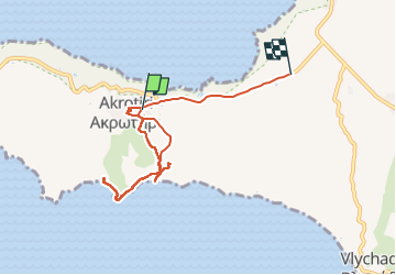
Randonnée de 8,5 km à découvrir à Égée, Περιφερειακή Ενότητα Θήρας, Δημοτική Ενότητα Θήρας. Cette randonnée est proposée par ezola.

Profil altimétrique

Localisation

Pays :
Grèce
Région :
Égée
Département/Province :
Περιφερειακή Ενότητα Θήρας
Commune :
Δημοτική Ενότητα Θήρας
Localité :
Unknown
Départ:(Dec)
Départ:(UTM)
356357 ; 4024895 (35S) N.

Randonnées à proximité

Randonnée Marche Δημοτική Ενότητα Θήρας - SANTORIN - Pyrgos - Perissa - GRECE - Photo
Marche
GUIDE
Michel1963

Marche

Moyen
Δημοτική Ενότητα Θήρας, Égée, Περιφερειακή Ενότητα Θήρας, Grèce
9,4 km | 15,5 km-effort
4h 19min
Non
Randonnée Marche Δημοτική Ενότητα Θήρας - Emporio - Profitis Ilias - Perissa - 10Km - Photo
Marche
potofe

Marche

Difficile
Δημοτική Ενότητα Θήρας, Égée, Περιφερειακή Ενότητα Θήρας, Grèce
10,2 km | 17,5 km-effort
3h 59min
Oui
Randonnée Voiture Δημοτική Ενότητα Θήρας - Santorin - Photo
Voiture
jcm17

Voiture

Très facile
Δημοτική Ενότητα Θήρας, Égée, Περιφερειακή Ενότητα Θήρας, Grèce
60 km | 73 km-effort
6h 17min
Non
Randonnée Bateau à moteur Δημοτική Ενότητα Θήρας - Santorin - Livadi - Milos - Sifnos - Photo
Bateau à moteur
lviallet

Bateau à moteur

Δημοτική Ενότητα Θήρας, Égée, Περιφερειακή Ενότητα Θήρας, Grèce
160 km | 166 km-effort
2h 50min
Non
Randonnée Marche Δημοτική Ενότητα Θήρας - Pyrgos Vothonas Exo Gonia _PE - Photo
Marche
pjjrevrard

Marche

Très facile
Δημοτική Ενότητα Θήρας, Égée, Περιφερειακή Ενότητα Θήρας, Grèce
6,2 km | 10 km-effort
3h 1min
Oui
Randonnée Marche Δημοτική Ενότητα Θήρας - Pyrgos Vothonas Exo Gonia  Panaghia Episkopi_PE - Photo
Marche
pjjrevrard

Marche

Très facile
Δημοτική Ενότητα Θήρας, Égée, Περιφερειακή Ενότητα Θήρας, Grèce
8,5 km | 15,1 km-effort
3h 1min
Oui
Randonnée Marche Δημοτική Ενότητα Θήρας - Emborio Profitis Elias Thira Perissa - Photo
Marche
pjjrevrard

Marche

Très facile
Δημοτική Ενότητα Θήρας, Égée, Περιφερειακή Ενότητα Θήρας, Grèce
8 km | 14,8 km-effort
3h 6min
Non
Randonnée Marche Δημοτική Ενότητα Θήρας - Pyrgos_Meso Gonia_Agios Georgios Katefyo_boucle - Photo
Marche
pjjrevrard

Marche

Très facile
Δημοτική Ενότητα Θήρας, Égée, Περιφερειακή Ενότητα Θήρας, Grèce
4,7 km | 8,4 km-effort
1h 48min
Oui
Randonnée Marche Δημοτική Ενότητα Θήρας - Pyrgos-Perissa par le Profitis Ilias - Photo
Marche
pjjrevrard

Marche

Très facile
Δημοτική Ενότητα Θήρας, Égée, Περιφερειακή Ενότητα Θήρας, Grèce
6,1 km | 10,6 km-effort
2h 52min
Non


Fermer
Mes abonnements